by Isobel Harry
Have you had any misery on Manitoulin this summer? If not (it’s not that easy, being miserable here), no worries, we’re all about a well-rounded vacation, mini-break or staycation, so jump aboard the train (that’s a figure of speech, there’s no train) to Misery Bay Provincial Park. No, you won’t be miserable, and yes, there’s a beach.
The story of the name goes something like this: Back in the dawn of time (or, in the 1880s), two men in a boat in the bay called out to settlers cutting marsh grass in the hot sun on the shore, “What bay is this?” An overheated wag in the work party shouted back, “Misery!” and the name stuck.
About 30 kilometres west of Gore Bay on Hwy 540, Misery Bay Provincial Park is a natural marvel: a 1,100-hectare tract of undisturbed, protected land with over 15 kilometres of well-marked and maintained trails on four distinct routes. Misery Bay Provincial Park is classified as a nature reserve by Ontario Parks to protect “at the highest level” the alvars, wetlands, upland forests and animal and plant species at risk that are found here.
Lay a day pass ticket on the dashboard and stroll over to the Visitor Centre. The door is open to this interesting eco-centre on stilts, but because of COVID, masks are mandated in here and the big, sunlit space is cordoned off to visitors; there is usually a volunteer to answer questions and give out maps, and the washroom is open. For now, it’s possible only to stand and gaze over the collections of butterflies, turtle shells, bones, bird nests and fossils native to the park; the books and binders on forest ecology, biology, geology and social history, photos and videos, interactive displays, kids’ activities, all remain out of reach this summer.
But much can be learned everywhere in the park; just under the Visitor Centre among the stilts are markers describing the visible striations of the hugely thick glaciers that scraped over these rocks, about 10,000 years ago, when the glaciers retreated as the last Ice Age was ending.
When the glaciers of Lake Nipissing melted, they left huge boulders and rocks in their wake over a moonscape of alvars, wide swaths of limestone pavements that host nearly 500 rare species of plants in their deep fissures and tiny cracks. Globally very rare, almost 75 percent of North America’s alvars are located in Ontario, according to the Nature Conservancy of Canada (NCC), carpeting a large portion of the paths and the beach in this forested park.
Take the 3.3 km Alvar Coast Trail to the beach in Misery Bay, a ‘moderate’ trail to hike, well-marked with red directional arrows. (The trail carries on along the coastline and loops back, a total of about eight km, but just to go to the beach and back is much shorter.) The slope down to the water is gently gradual, the path sometimes firm sand, sometimes flat, limestone alvars, sometimes pine-needle-strewn, always clearly discernible as it weaves through thick stands of trees. Even before reaching the beach, we are already ‘forest bathing,’ experiencing the scientifically-documented rejuvenating effects of spending time in nature, especially in a forest.
Given the stunning geological environment in which the park is situated, it stands to reason that the beach will not be just your usual beach (never a bad thing in itself, of course), but also a geological wonder. And it’s a 20-minute walk, adding another healthy dimension to the beach experience; for this reason, a pair of shoes slightly sturdier than flip-flops is recommended for the trail. As on any hike, water and snacks are de rigueur.
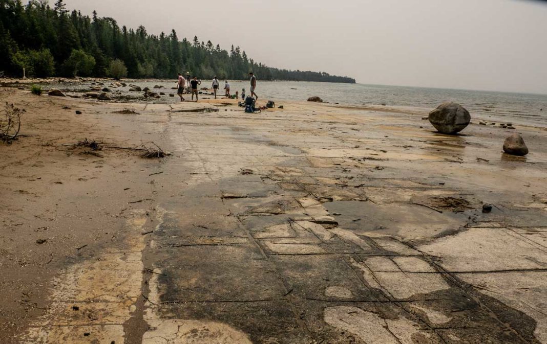
This beach is indeed different; arriving on the shore of Misery Bay is a bit like stumbling into a movie set in primeval times. Water levels have receded since last summer’s high levels submerged all of the beach, but are still not as low as in recent years, when the now-lake-bottom became visible, alvars stretching out as far as the eye could see.
Today, the sandy beach is back, and a nice one it is: a golden horseshoe set in a half circle of cedars backs a shallow water landscape of alvars and enormous glacial-era boulders and rocks.
You’d have to go out farther to actually swim, but everyone here seems content to explore the unusual terrain and to stretch out on the huge flat rock bed a few inches above the water; adults and kids linger and splash around the edges, sitting and standing in amazement.
The sandy part of the beach invites relaxation, but today, people are hiking up and down the coast and wading in the cooling water; a shelter/gazebo offers rest and a shady spot for lunch. As they tuck into their sandwiches, two groups exchange stories of returning here year after year, irresistibly drawn by the unique adventures of this prehistoric place.
***
A look around the Friends of Misery Bay website is strongly recommended, for trail maps, descriptions and photos of various habitats, flowers, plants and geological formations that are to be seen in the park and much else that will enhance any visit. miserybay.ca
***
The park is for day use only; no camping is allowed. Day use fees are in effect only on Friday, Saturday and Sunday. There is no charge for day use from Monday to Thursday until September 5, 2021.
Day use fees are for a vehicle with all occupants included: Regular, $12.25; senior, $9.75; person with disabilities, $6. The ‘pay and display’ machine is in the parking lot at the trail entrance that leads to the Visitor Centre.
The Visitor Centre’s door is open but the centre is not accessible to visitors at this time.
Hours: Monday to Friday from 10 am to 5 pm and on weekends from 11 am to 4 pm. The washrooms are open seven days a week.


