To the Expositor:
I believe that an extra set of bumpers for the Chi-Cheemaun dock is a Band-Aid at best.
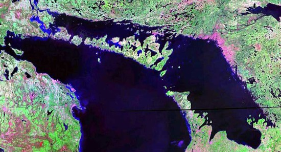
Most people have known for some time that Lake Huron is in trouble. While we knew there was a problem, it wasn’t clear as to the source of the problem.
Finally, with the 2013 International Joint Commission (IJC) report, the IJC seems to agree with what most others have known for some time.
I suggest Lake Huron is the “canary in the coal mine.” Next came the Chi-Cheemaun and its docking problem due to low water levels. Next it will be the other Great Lakes, not far behind. Will the planets eco-system follow close behind that?
In a graph from the Baird Report (see http://pub.iugls.org/en/Other_Publications/Baird_Report.pdf), Canadian hydrological engineering experts hired by Georgian Bay Association to study water levels in Lake Huron-Georgian Bay in 2005. The graph shows the level difference between Lake Huron and Lake Erie is getting smaller and smaller. This change in levels is blamed on: impact of the dredging of the St. Clair River to deepen the shipping channel on three occasions; building of groins along the beaches on the south shore of Lake Huron (which prevent a fresh supply of sand and gravel from being carried into the St. Clair River), replenishing what is scoured from the river bottom by the swift current; sand and gravel mining that used to occur in the St. Clair River and at its inlet at the south end of Lake Huron (ie. ships suck up sand from river bottom and sell it to customers. They removed more than 350 years worth of accumulated sand and gravel); changing inflows and outflows from Lake Huron (weather effects); and the scouring of the St. Clair River bottom by rapidly flowing water. The scouring changes the river’s underwater profile, making the channel deeper, reducing the streambed roughness, and increasing the river’s flow capacity.
Note that the IJC has consistently chosen to minimize the size of the problem as communicated to the public.
Other studies have noted extreme changes in the St. Clair river’s conveyance capacity (see http://pubs.usgs.gov/sir/2009/5080/pdf/SIR20095080.pdf) that would indicate huge increase in flow capacity (conveyance) in the St. Clair River around 1968, six years after the last dredging. The authors of this study were shocked by their results, and couldn’t believe they were true, and assumed that somebody had made a mistake in the lake level measurements and flows, so as to explain their “crazy” results.
However, there now appears to be support for the theory that with reduced sand and gravel entering the St. Clair river (due to groins built along both US and Canadian shores to keep the waterfront property owner’s sandy beach in place and minimize their waterfront erosion, for example from Sarnia to Kettle Point), that a glacially laid down clay bottom (14,000 years old) in the St. Clair river was exposed by the dredging and the loss of gravel cover (swept down river, and not replaced by new sand and gravel from Lake Huron). The exposed clay in the river bottom was quickly eroded away, thereby rapidly increasing the river’s ability to flow, so as to more rapidly drain Lake Huron ever since. The hole is just South of the bridge between Sarnia and Port Huron.
If rock is not added to the bottom to protect the clay river bottom, it will continue to erode until the river is so deep that the stream velocity is reduced, and the scouring of the river bottom slows down, then stops. That continuing change to St. Clair River will more and more increase the flow capacity of the river for the same lake level, crating far greater flow capacity than what has ever occurred before historically, and the Lake Huron lake level will continue to drop until a new equilibrium is reached (ie. Lake Huron is drained and can no longer flow down the river, but a trickle).
The 2013 IJC report (http://ijc.org/files/publications/IUGLS-IJC-Report-Feb-12-2013-15-April-20132.pdf) outlines that one third of the water loss from Lake Huron is evaporation, most of which occurs in the winter when you have relatively warm lake water and cold, dry air blowing over the lake surface, which is then heated by the warmer water, and the warmer extremely dry air evaporates water from the lake and becomes saturated in moisture. When there is little or no ice cover on the lake, that is when we lose huge amounts of water from the lake surface, dropping our lake levels. The evaporation from the Lake in winter is many times greater than what occurs in summer. With global warming, there is less and less ice on the lake during winter, the ice arrives later in the fall, and leaves the lake sooner in the Spring. (See www.glerl.noaa.gov/pubs/brochures/ice/ice.pdf.)
Annual average ice cover (December to April) showed a relative overall decline of 63 percent on the Great Lakes from 1973 to 2011, and a simultaneous 76 percent drop on Lake Superior for ice cover. That is a 38-year base time interval, at an average exponential drop of 4.69 percent per year. At that rate, the ice cover is halfed every 15 years (ie. half life of 15 years). So far, we have gone through four doublings, for our average ice coverage is around 10 percent of the lake surface. After a total of 49 doublings, we will only have ice equivalent to an ice cube (one square inch of ice left) on the surface of the entire Lake Huron. We will suffer the full effect of global warming long before we get to that stage.
A 76 percent drop of anything in nature is huge. Think extinction of the dinosaurs.
The surface waters of the Great Lakes are also warming (see www.solecregistration.ca/documents/Surface%20Water%20Temperature%20DRAFT%20Oct2011.pdf). For Lake Huron, the date of the onset of summer stratification of temperatures in Lake Huron is occurring earlier at a rate of roughly 0.6 +/- 0.3 days per year. This date is correlated with the ice cover achieved in the previous winter. This temperature stratification date is consistent between two National Data Buoy Centre (NDBC) buoys stationed in the lake. The graphs below show similar trends for Lakes Superior, Michigan, and Huron.
This same ice effect is occurring in the far north on the sea ice. Soon, when all of the sea ice is gone and we have dark ocean that absorbs the sun’s energy rather than the white snow that reflect the radiation back out to space, we will likely have passed a tipping point, and we will then be past a point of no return for earth’s climate.
I therefore suggest that the Great Lakes are the front lines of the climate change battle ground. This is where we need to stand and fight, where we need to make a stand for climate change, and change the ice cover trend, and save Lake Huron.
The Lake Huron inflows are approximately one third from Lake Superior, one third from precipitation on the lake surface, and one third from watershed runoff from the lands surrounding Lake Huron. Each of these in-flows is affected by climate change. Therefore the effect of climate change on Lake Huron water levels is huge. If we get hotter, dryer weather due to climate change, the lake evaporation increases, the precipitation onto the lake decreases, the inflow from Lake Superior decreases, and the runoff from the Lake Huron watershed decrease. A small change in the weather creates a huge drop in the inflows to Lake Huron. We may assume that if the climate change is X percent, the impact on Lake Huron may be as high as four time X percent (I’m in the process of doing a computer simulation to better estimate this effect). There are good reasons to believe that, of all the Great Lakes, the impact of climate change on Lake Huron is the biggest of all.
Lake Huron is the canary in the coal mine.
I think that is why the chairperson of this 2013 IJC report refused to sign off with the majority. She was worried that the government would respond only to the St. Clair River flow issues, and ignore their responsibilities, and need for action, on climate change; the greatest driving force of all on Lake Huron.
The Chicago diversion canal is only one percent of the total outflow, and is therefore insignificant compared to these other effects.
While the issue of Lake Huron outflow to the St. Clair River needs to be (and can be) fixed fairly quickly, we also need a fix to the climate change issue. If we don’t fix both these issues, Manitoulin Island will continue to grow in size as the water retreats further and further from shore. We will be left high and dry as Lake Huron slowly disappears.
Glenn Black Providence Bay


