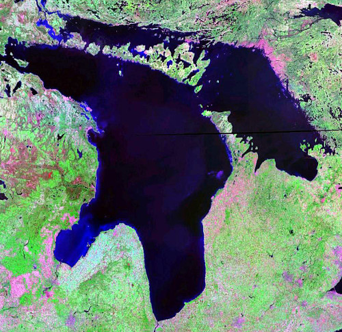
DOMINION BAY—While levels for other Great Lakes are above historical chart datum, levels in Michigan-Huron have reached all time lows and require a positive decision to come from the International Joint Commission (IJC) on taking steps to rectify this situation, says a representative of the Manitoulin Area Stewardship Council.
“The IJC had extended the date for submissions and comments on their report and I decided to take advantage of this as a last kick at the can,” said Mike Wilton on Monday. “The levels in Lakes Michigan-Huron are below the chart datum and it appears they are going to continue to drop. The U.S. Army Corps of Engineers is predicting the levels are going to take more, serious drops for Michigan-Huron, while the other lakes are above the historical chart datum.”
In two letters to the IJC, Mr. Wilton outlines his concerns and the reasons for them. In the first, “Have We Missed the Boat?” he states, “the St. Lawrence Seaway is in imminent danger of self-destruction. The untoward dropping of water levels in the Lake Huron-Michigan Basin means that more water must be fed into the system to keep the channel sufficiently deep for ships to pass through it. This in turn means that more water must be siphoned from Lake Superior to keep the system viable.”
“But can Superior continue to supply the necessary water?” asks Mr. Wilton. “Probably not under present and predicted conditions of temperature and precipitation. So, in order to keep the shipping lanes open, Lake Superior will be dragged down to the point that both Superior and Huron-Michigan are compromised.”
“There is no upper lake beyond Superior, no further capital to spend, so the buck must stop here! With us!” wrote Mr. Wilton. “Examination of the attached USAGE updated Great Lakes levels chart, indicates that at the present time, i.e. September 30, 2012 all the Great Lakes are above chart datum, with the exception of Lake Huron-Michigan. As of this date, Lake Huron-Michigan is five inches below datum and is predicted to reach an unprecedented level more than 15 inches below datum by mid-February. This means that rocks under water for more than 10,000 years will be bared for the first time!’
Mr. Wilton continued, “if Lakes Superior and Michigan-Huron are to be saved, then the only sensible approach is to deal with the Huron-Michigan basin before Superior is reduced to the point of no return.
I feel that our best hope is the placing of permanent structures at the mouth of and possibly for a distance downstream, in the St. Clair River. These structures would be placed outside the shipping lane and would impede river flows, thereby reducing current. Through time this would gradually raise and restore the level of Lake Huron, without seriously changing conditions downstream. To me this is the practical approach to multi-lake regulation.”
“My approach is admittedly over simplistic, but I feel that it is feasible from both an engineering and cost standpoint,” continued Mr. Wilton in his letter to the IJC. “Whatever solution is deemed to be the most practical, the logical location for its implementation is in the upper reaches of the St. Clair River. “I urge the members of the International Joint Commission to please act quickly and decisively.”
In a separate summary of concerns to the IJC, dated September 30, 2012, Mr. Wilton writes, “to say that Manitoulin Island residents and visitors are concerned regarding diminishing water levels is a serious understatement.”
“Manitouliners are thoughtful, quieter people, not often given to loud outbursts and, as a result, are perhaps less inclined to speak out publicly than their southern counterparts, but this is different,” wrote Mr. Wilton. He explained, “more than 3,614 Islanders and visitors have stepped up to sign a petition seeking assistance from the Canadian government to stop and reverse the ongoing critical loss of water from the Lake Huron/Michigan/North Channel/Georgian Bay Basin.”
“Probably the most significant loss from dropping water levels is what is happening to wetlands in what was formerly the most productive series of wetland areas on the Great Lakes; that is the Georgian Bay, North Channel and Manitoulin Island shorelines. Natural annual water fluctuations are normal and expected, adding to the health and richness of wetland areas,” wrote Mr. Wilton. “But the continuing drawdown that has been experienced over the last dozen years has led to the permanent loss of entire waterfowl marshes, fish spawning areas and the habitat necessary for reptile and amphibian populations to successfully reproduce.”
“In addition to the above, resident landowners, cottagers and marina operators have watched helplessly as their shoreline receded and was replaced by invasive weed species,” wrote Mr. Wilton. “Presently, water levels continue to drop below previous lows at an alarming rate, especially since Labour Day. Is this coincidence or manipulation? It happens every year!”
The term”adaptive management” has been introduced as a possible means of coping with this ongoing crisis, said Mr. Wilton. “To me, adaptive management merely means accepting the inevitable and making do with stop-gap methods that are ultimately desgined to fail,” said Mr. Wilton. “To suggest (as one engineer did) that dykes could be built around wetlands to hold water at present levels, is merely an excellent example of a total lack of understanding as to how natural ecosystems function. Examples such as this should serve to prove that greater care and understanding are needed if ‘sensible and practical’ decisions are to be made regarding the needs of the Great Lakes.”
“Multi-lake management” is another term recently coined, which has wide variability of meaning and has not been adequately defined,” wrote Mr. Wilton. “It appears to mean anything from the installation of permanent water-flow control structures at the mouth of the St. Clair River ( a practical, doable idea) to huge engineering undertakings downstream through the course of that river, which appear to be aimed mainly at providing engineering opportunities for the U.S. Army Corps of Engineers.”
Mr. Wilton writes, “surely, there is enough combined Canadian-U.S. engineering expertise available, that for a reasonable cost, permanent structures could be designed and installed at the mouth of the St. Clair River, that would not only restabilize the river bottom, but would gradually through time, be capable of reestablishing former water levels, without negatively affecting downstream concerns.”
“While cost will obviously be touted as prohibitive, we see everyday examples of “governmental funding misguidance” whereas we will seldom be presented with a better investment opportunity for our children and our children’s children than this,” wrote Mr. Wilton. “Global warming and tectonic plate shifting are probably contributing factors to the present situation as well. However, the former is as yet improperly understood and the latter is uncontrollable. So let us deal with that which we understand.”
Mr. Wilton added that, “humans have been manipulating the Great Lakes waterways for generations. Probably that was a mistake from the beginning. However, it is possible and feasible that with the knowledge available today, our two nations can resolve this problem and ensure that future generations will not be left with dry holes.”


